Starting from €8,010.00
Precision Velocity Sensing for ROV Navigation & Autonomy
Water Linked Doppler Velocity Logs (DVLs) deliver highly accurate velocity data that enables reliable position hold, dead‑reckoning, and autonomous navigation for underwater vehicles such as the BlueROV2 and other professional ROV platforms.
Designed for demanding subsea operations, Water Linked DVLs combine compact form factors with robust performance across a wide operating envelope.
DVL Model Options
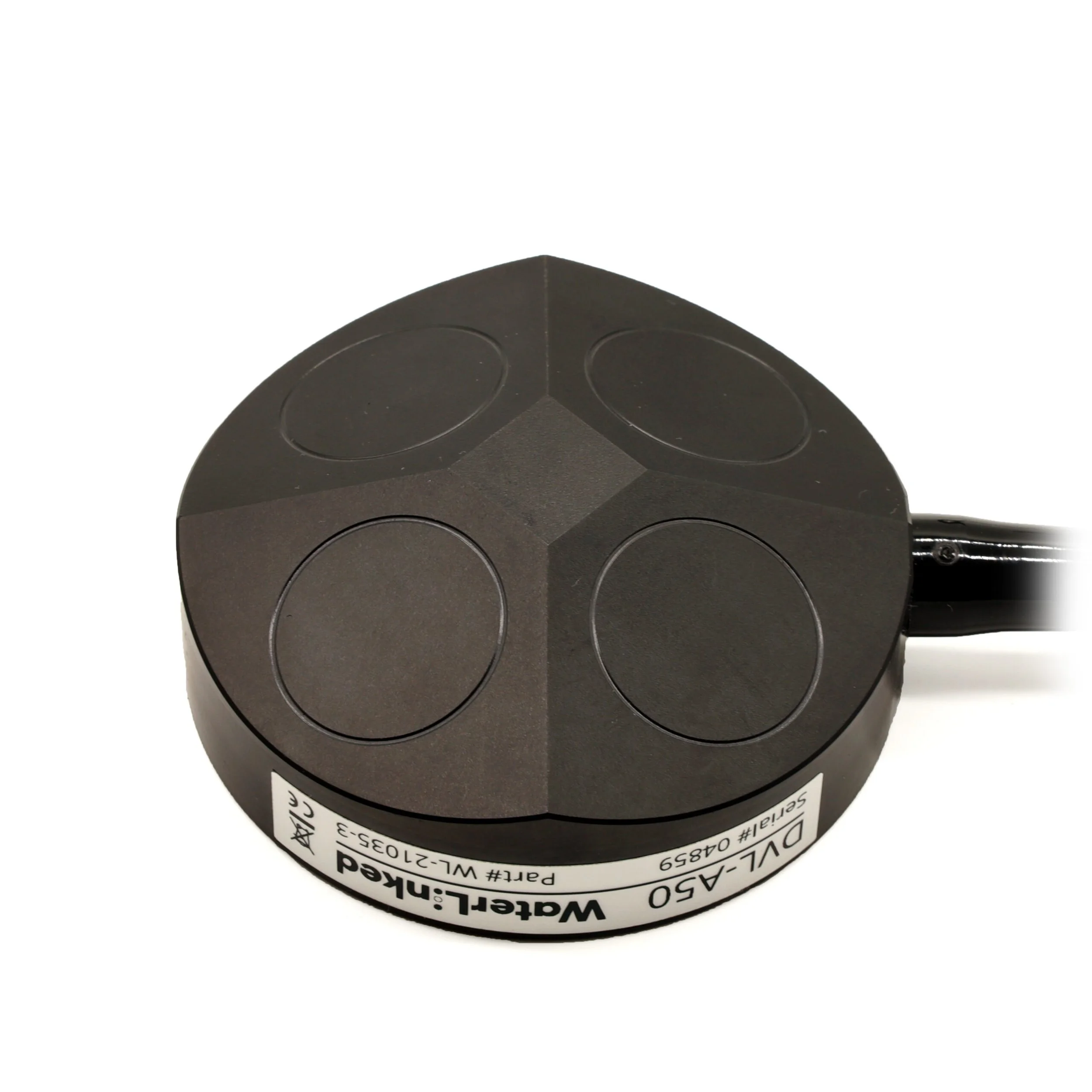
DVL A50
Ultra‑compact design – among the smallest DVLs available
Operational range: 5 cm to 50 m above seabed
Depth rating: up to 300 m
Ideal for small ROVs and confined underwater environments
Water Linked A50 DVL
From €8,010
Water Linked Doppler Velocity Logs (DVLs) deliver highly accurate underwater velocity measurements, enabling position hold, station keeping, and autonomous navigation for the BlueROV2 and other ROVs or AUVs. Designed and manufactured in Norway, these compact DVLs combine professional‑grade performance with easy integration.
DVL A50
Operating altitude: 5 cm to 50 m above seabed
Depth rating: 300 m
Ideal for small ROVs and close‑to‑bottom operations
Why Use a DVL?
A Doppler Velocity Log measures vehicle speed relative to the seabed using acoustic transducers and the Doppler effect. By continuously tracking velocity, the DVL enables precise relative positioning underwater, even where GPS signals are unavailable.
When combined with GPS or USBL systems, a DVL forms the foundation for reliable global underwater navigation.
Advanced ROV Capabilities
Adding a Water Linked DVL unlocks powerful features, including:
Position hold and station keeping
Waypoint and guided navigation
Survey grid execution
Reduced pilot workload and smoother operations
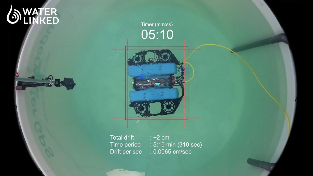
Even without an external positioning system, position hold works using the DVL alone.
Compact, Powerful, and Easy to Integrate
Integrated WetLink penetrator
Ethernet and serial (JST GH) connectors
10–30 V power input with spade terminals
Optimized for BlueOS with a one‑click extension
Built for Professional Applications
Supported in BlueOS via the Water Linked DVL extension
Compatible with Water Linked API and PD6 protocol
Designed for ROVs, AUVs, research platforms, and industrial inspection vehicles
Featured Products
From Price: €8,290.00
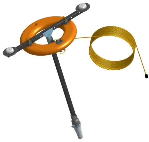
The Omnitrack Underwater Positioning System is a modern, high‑precision solution for tracking and positioning underwater vehicles and assets. Designed for professional marine operations, Omnitrack combines advanced surface positioning technology with seamless ROV integration to deliver reliable and repeatable underwater navigation.
Advanced Surface Positioning with GNSS Heading
At the heart of the system is a rugged surface positioning buoy, engineered to operate as a stable reference point on the water. Equipped with dual GNSS receivers, the surface module provides highly accurate global positioning while simultaneously calculating true heading. This dual‑GNSS design removes common errors caused by magnetic interference, ensuring dependable orientation in challenging environments.
Accurate Underwater Target Tracking
The surface unit works in conjunction with an integrated acoustic locator to precisely track underwater targets. This makes Omnitrack ideal for:
ROV navigation and survey missions
Inspection and mapping tasks
Scientific research and offshore operations
Optimized for BlueROV Integration
Omnitrack is designed to interface directly with BlueROV systems, significantly improving the vehicle’s internal position estimation. For enhanced performance, the system can also be paired with a Tracker‑650 DVL, enabling smoother navigation and higher accuracy during complex underwater maneuvers.
Flexible Deployment Options
To suit different operational needs, the surface module is available in both:
Wired configurations for maximum stability
Wireless configurations for rapid deployment and operational flexibility
Key Benefits
High‑accuracy GNSS‑based surface positioning
True heading without magnetic interference
Improved ROV navigation and situational awareness
Compatible with BlueROV and optional DVL systems
Designed for professional and research‑grade applications
Starting from €2,750.00
Estimated Shipping Time: approx. 3 weeks
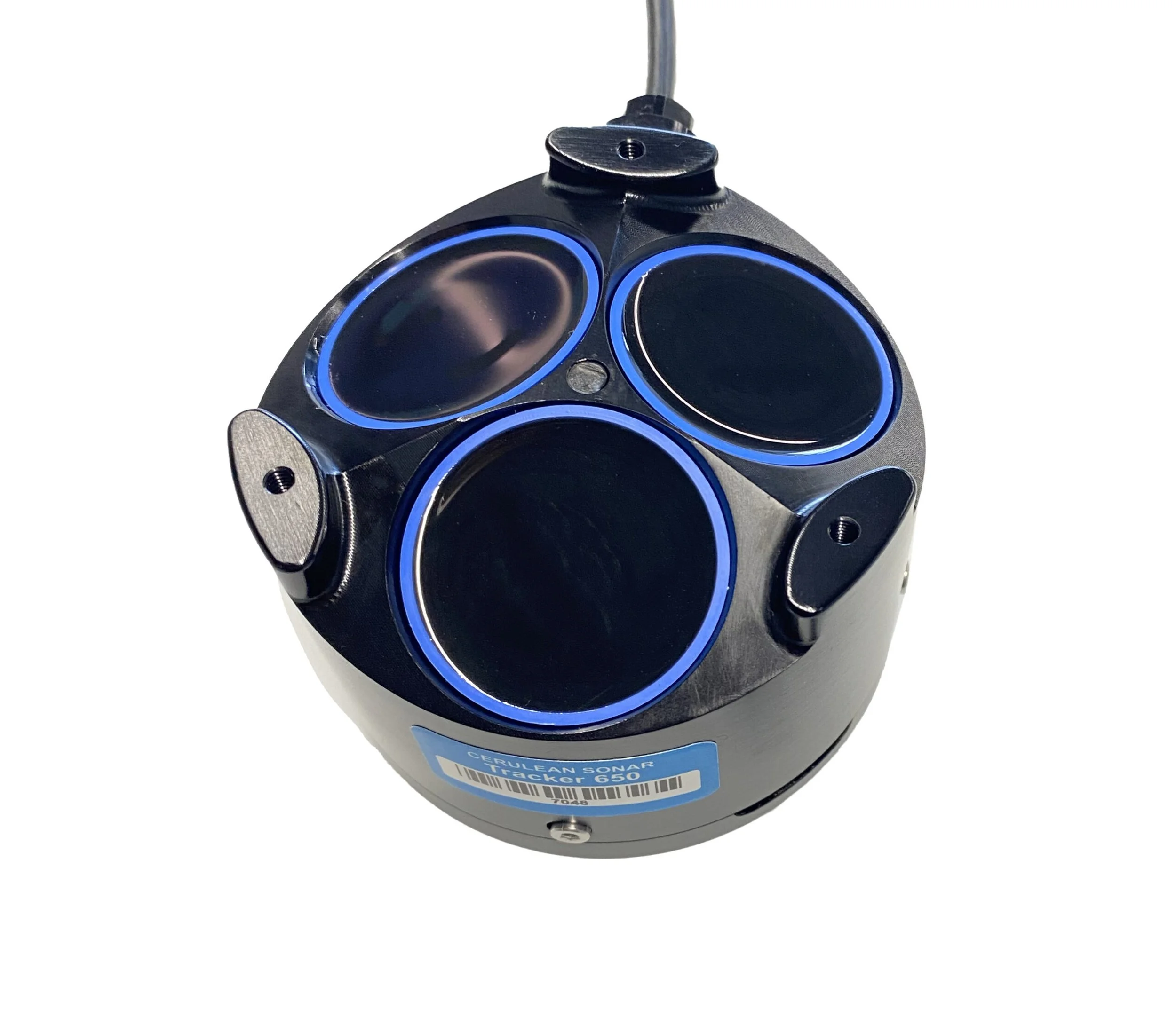
High‑Performance Velocity Logging for ROV Integration
The Tracker 650 Doppler Velocity Log (DVL) is purpose‑built to deliver exactly what modern ROVs require: precise velocity data for reliable station keeping, position hold, and advanced navigation control.
By focusing purely on velocity measurement, the Tracker 650 avoids unnecessary complexity and cost. Instead of incorporating an internal attitude sensor, it intelligently relies on the vehicle’s existing IMU as the primary reference for orientation. This streamlined approach reduces system redundancy, minimizes calibration effort, and simplifies overall integration.
Designed for OEMs and Professional ROV Platforms
The Tracker 650 is an excellent choice for ROV manufacturers and system integrators looking for a compact, efficient, and dependable DVL solution. It integrates seamlessly into new or existing underwater vehicle platforms and supports advanced stabilization and tracking algorithms within the vehicle’s control system.
Cerulean provides comprehensive technical documentation and engineering support, ensuring smooth OEM integration from prototype to production.
Key Benefits
Accurate velocity data for underwater navigation
Optimized for position hold and tracking applications
No built‑in IMU – reduced complexity and calibration time
Ideal for OEM and professional ROV integration
Backed by full engineering and documentation support
Water Linked DVL Systems
Starting from €10,710.00
Precision Velocity Sensing for ROV Navigation & Autonomy
Water Linked Doppler Velocity Logs (DVLs) deliver highly accurate velocity data that enables reliable position hold, dead‑reckoning, and autonomous navigation for underwater vehicles such as the BlueROV2 and other professional ROV platforms.
Designed for demanding subsea operations, Water Linked DVLs combine compact form factors with robust performance across a wide operating envelope.
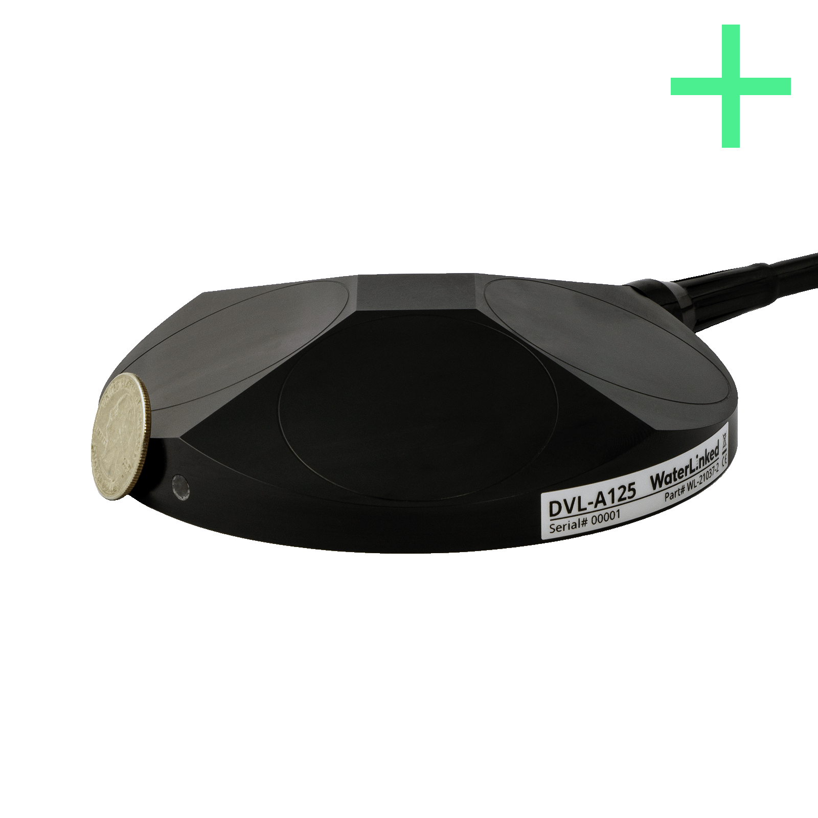
DVL A125
Larger, more powerful DVL for extended missions
Operational range: up to 125 m above seabed
Depth rating: up to 600 m
Optimized for deeper water and long‑range navigation
Both models provide ±1% long‑term velocity accuracy, ensuring consistent and repeatable navigation performance over time.
Integration Notes
Required for BlueROV2: Ethernet switch (not included)
Compatible with autonomous navigation and positioning workflows
Well‑suited for research, inspection, survey, and industrial ROV use
Key Benefits
High‑accuracy velocity measurements
Supports position hold and autonomous navigation
Compact, ROV‑friendly design options
Proven performance in shallow and deep water
Seamless integration with modern ROV systems