From Price: €8,290.00
The Omnitrack Underwater Positioning System is a modern, high‑precision solution for tracking and positioning underwater vehicles and assets. Designed for professional marine operations, Omnitrack combines advanced surface positioning technology with seamless ROV integration to deliver reliable and repeatable underwater navigation.
Advanced Surface Positioning with GNSS Heading
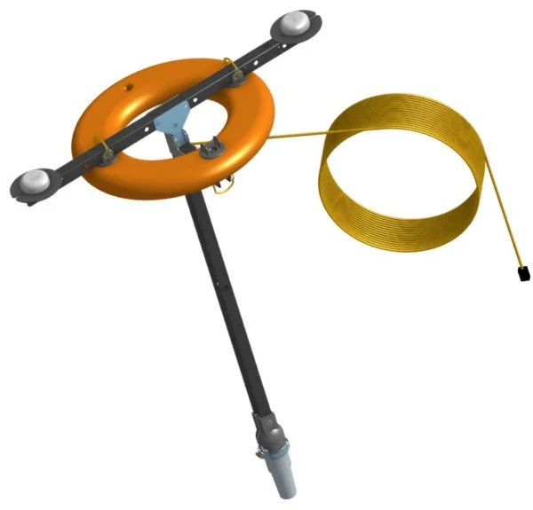
At the heart of the system is a rugged surface positioning buoy, engineered to operate as a stable reference point on the water. Equipped with dual GNSS receivers, the surface module provides highly accurate global positioning while simultaneously calculating true heading. This dual‑GNSS design removes common errors caused by magnetic interference, ensuring dependable orientation in challenging environments.
Accurate Underwater Target Tracking
The surface unit works in conjunction with an integrated acoustic locator to precisely track underwater targets. This makes Omnitrack ideal for:
ROV navigation and survey missions
Inspection and mapping tasks
Scientific research and offshore operations
Optimized for BlueROV Integration
Omnitrack is designed to interface directly with BlueROV systems, significantly improving the vehicle’s internal position estimation. For enhanced performance, the system can also be paired with a Tracker‑650 DVL, enabling smoother navigation and higher accuracy during complex underwater maneuvers.
Flexible Deployment Options
To suit different operational needs, the surface module is available in both:
Wired configurations for maximum stability
Wireless configurations for rapid deployment and operational flexibility
Key Benefits
High‑accuracy GNSS‑based surface positioning
True heading without magnetic interference
Improved ROV navigation and situational awareness
Compatible with BlueROV and optional DVL systems
Designed for professional and research‑grade applications
Omnitrack Underwater Positioning System
Price from €8,270.00
Advanced Underwater Positioning for Professional ROV Operations
Omnitrack is a next‑generation underwater positioning system developed for accurate and reliable tracking of subsea assets. Designed by Cerulean Sonar, the system delivers precise global positioning and heading data for underwater targets, even in environments where traditional navigation systems struggle.
At the center of the solution is the Omnitrack surface module—a robust floating ring buoy that combines an acoustic ROV locator with dual GNSS receivers. This configuration ensures stable and accurate positioning of underwater vehicles while providing precise heading information without relying on magnetic sensors.
GNSS‑Based Heading Without Magnetic Distortion
By using two GNSS receivers, Omnitrack determines heading independently of magnetic compasses. This eliminates errors caused by steel structures, vessels, or subsea infrastructure and ensures dependable orientation data during inspections, surveys, and complex maneuvers.
The result is a cleaner and more reliable navigation solution for professional underwater operations.
Direct Integration with BlueROV and DVL Systems
Omnitrack is designed to interface directly with the BlueROV platform and can optionally be paired with the Tracker‑650 DVL. This combination enhances the ROV’s internal position estimate, improving navigation accuracy and operator confidence during demanding missions.
Wired and Wireless Surface Module Options
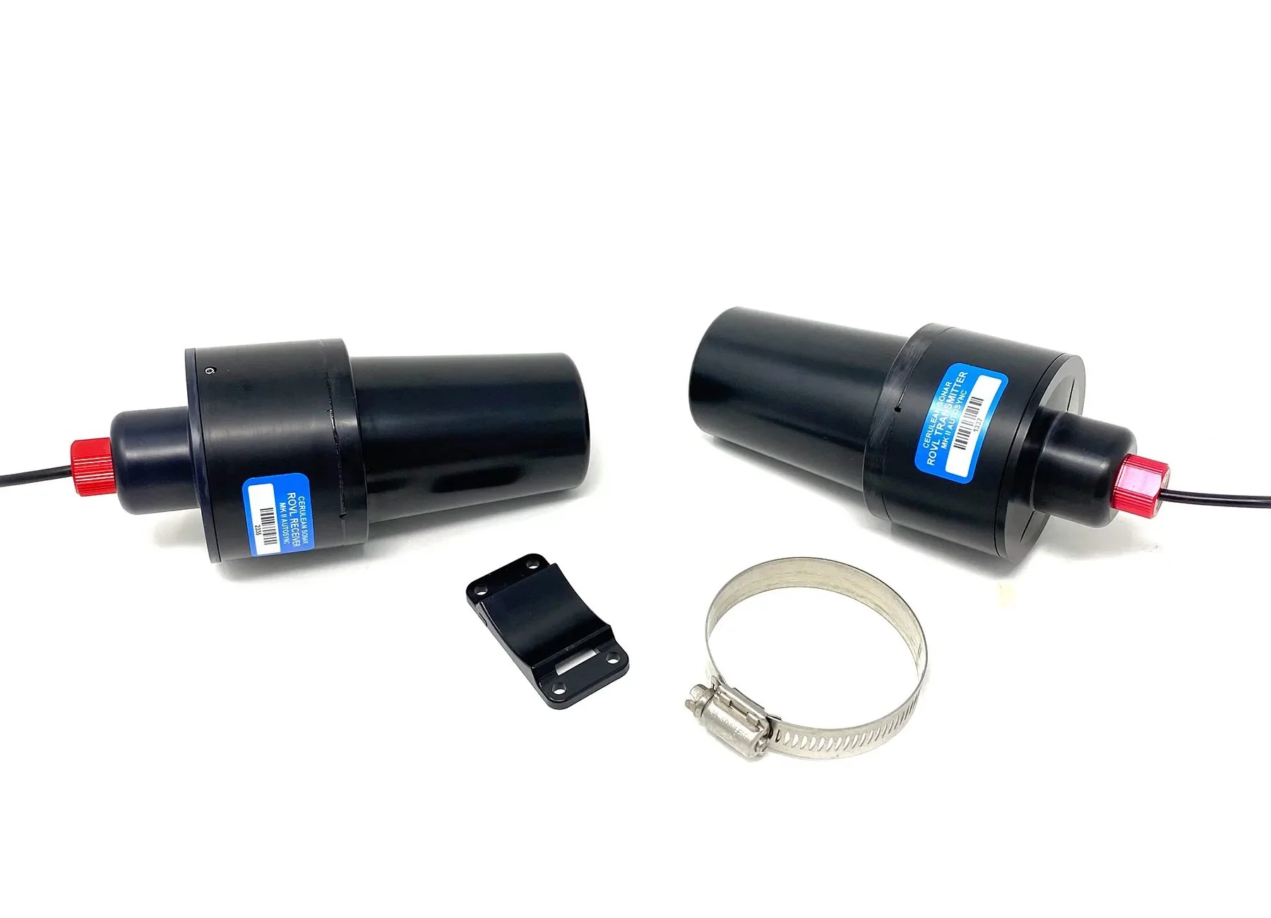
Wired Omnitrack – PoE Tether + Network Hub
From €8,270.00
25 m strong, neutrally buoyant PoE tether
Single‑cable power and data transmission
Network hub included for power injection and network bridging
Reliable and interference‑free connection for continuous operations
The wired version is ideal for users who prioritize maximum stability and uninterrupted power to the surface module.
Wireless Omnitrack – Wi‑Fi Module + Network Hub
From €9,190.00
Integrated Wi‑Fi communication module
Untethered surface buoy for faster deployment
Network hub included
Greater flexibility for mobile and temporary operations
The wireless configuration is well suited for rapid setups and applications where a physical tether is not desirable.
Technical Specifications
Maximum depth rating: 300 m
Maximum operating range: 300 m
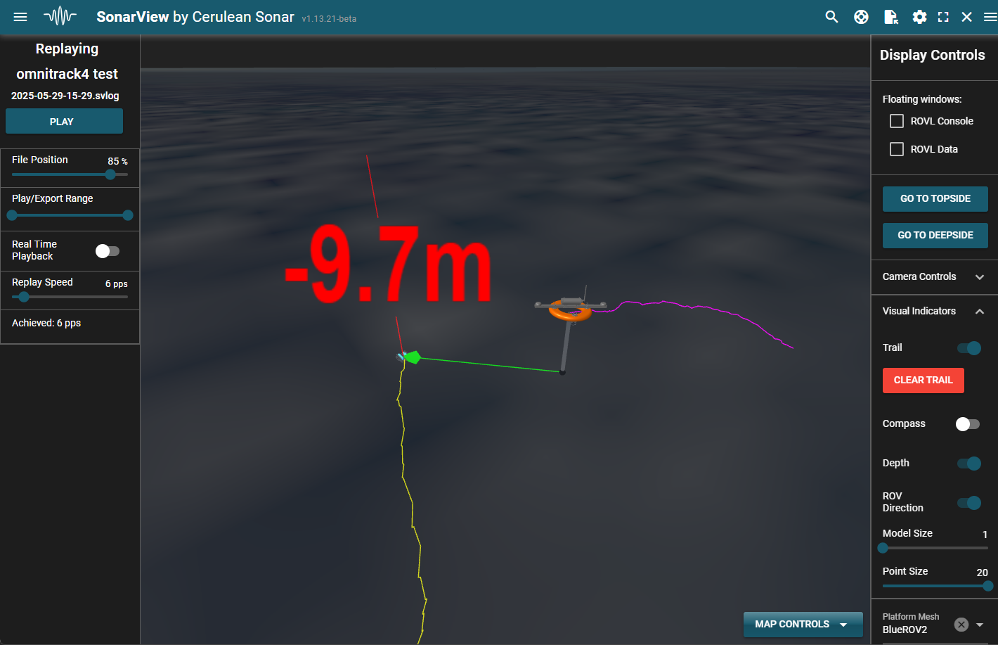
Position update rate: 1 Hz
Surface module: GNSS‑enabled acoustic buoy
Connectivity options: Wired (PoE) or Wireless (Wi‑Fi)
For complete technical details, please refer to the official Omnitrack reference documentation.
Typical Applications
ROV navigation and tracking
Underwater inspection and surveying
Marine research and data collection
Offshore, port, and harbor operations
Subsea infrastructure monitoring
Featured Products
Price From : €3,210.00
Estimated Shipping Lead Time: ~3 weeks
The ROVLe Bundle Mark II is a compact and cost‑efficient underwater positioning solution designed for ROV operators who need fast deployment and reliable performance without complex setup procedures. With an impressive depth rating of up to 300 meters, this system is well suited for inspection, survey, and light commercial underwater operations.
Fast Setup, Minimal Configuration
Unlike traditional acoustic positioning systems, the ROVLe Mark II eliminates time‑consuming pre‑mission calibration. There is no requirement to calibrate crystal oscillators or manually synchronize distances between units before deployment. This allows operators to get operational quickly, reducing downtime and simplifying field operations.
Reliable Underwater Tracking
The system delivers consistent and dependable underwater positioning, making it ideal for:
ROV navigation and maneuvering
Visual inspection tasks
Marine research and data collection
Training and educational use
Its streamlined design focuses on reliability and ease of use, offering professional‑grade performance at a highly accessible price point.
Key Features & Benefits
Depth rating up to 300 m
Rapid deployment with no complex calibration
Cost‑effective alternative to traditional positioning systems
Designed for efficient ROV operations
Ideal for commercial, research, and educational users
Price from: €5,510.00
Estimated Shipping Lead Time: ~3 weeks
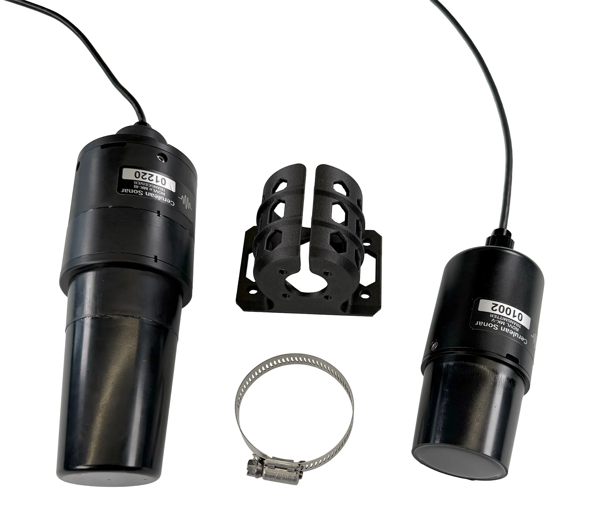
The ROVLe Bundle Mark III is a next‑generation underwater positioning solution designed for operators who demand maximum ease of use, long‑term stability, and software flexibility—all in a cost‑efficient package. Built for professional ROV operations, the Mark III delivers accurate positioning with minimal setup and zero ongoing calibration concerns.
Rapid Deployment with Powerful Software Options
The system includes the intuitive SonarView topside software, allowing operators to begin missions quickly with a clear, user‑friendly interface. For advanced users and integrators, the open API enables seamless integration with custom control systems, survey software, or research platforms—making the Mark III highly adaptable to diverse operational workflows.
Stable Accuracy with No Timebase Drift
Engineered for long-duration deployments, the Mark III features no timebase drift, meaning the system maintains consistent slant‑range accuracy even during extended or indefinite submersion. With a depth rating of up to 300 meters, it is well suited for inspection, survey, and research missions where reliability over time is critical.
Ideal for Professional and Research Applications
The ROVLe Bundle Mark III is an excellent choice for:
ROV navigation and positioning
Subsea inspection and survey work
Scientific and academic research
Custom software and system integration
Key Features & Benefits
Depth rating up to 300 m
No timebase drift for long‑term accuracy
Supplied SonarView topside software
Open API for custom integration
Fast setup with minimal configuration
Cost‑effective alternative to complex positioning systems
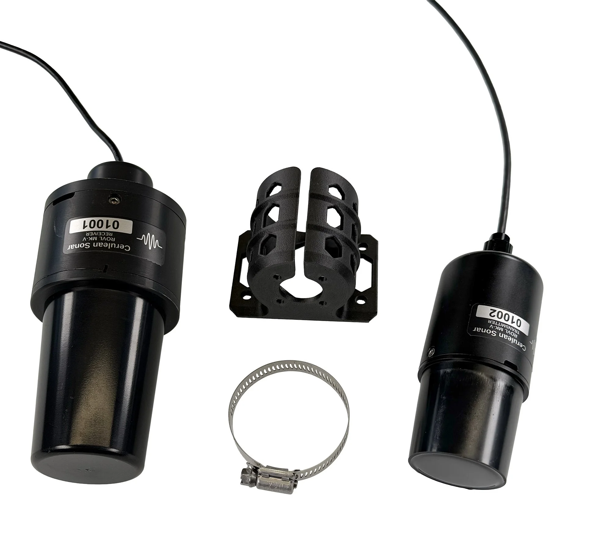
Price from: €4,410.00
Estimated Shipping Lead Time: ~2 weeks
The ROVLe Bundle Mark V is a modern, network‑enabled underwater positioning solution designed for reliable and efficient ROV operations. As part of Cerulean’s latest subsea positioning ecosystem, the Mark V introduces Ethernet‑based networking to deliver stable and accurate timing synchronization between surface and subsea components.
Ethernet Synchronization for Improved Stability
Unlike traditional systems that rely on standalone timing methods, the Mark V uses a direct Ethernet connection to synchronize timing between the topside receiver and the subsea transmitter. This network‑based architecture enhances system stability, reduces timing uncertainty, and supports consistent underwater range measurements during operations.
Designed for Professional ROV Operations
The ROVLe Mark V is well suited for operators who require a balance between simplicity, performance, and modern system integration. Its streamlined design makes it ideal for:
ROV navigation and positioning
Subsea inspection and observation
Marine research and field operations
Network‑based control and monitoring setups
Fast Deployment, Minimal Complexity
With a focus on ease of use, the Mark V allows crews to deploy quickly without complex configuration procedures. The Ethernet‑enabled design also makes it easier to integrate into existing onboard networks and control systems.
Key Features & Benefits
Network‑enabled ROV locator system
Ethernet synchronization between topside and subsea units
Stable and reliable underwater positioning
Designed for modern ROV workflows
Fast setup and efficient deployment
Part of Cerulean’s evolving subsea positioning ecosystem